Attention! Bair Island and Corkscrew Slough
Bair Island: for the adventurous ...
ALWAYS TAKE YOUR PHONE IN A DRY POUCH WITH A FLOATER AND ATTACH IT TO YOUR BOAT!!!
Be very cautious when going in Bair Island. There is mud but there are also poles and iron bars that might not be visible and can hurt your boat.
Whether you are a BIAC member or a harbor visitor launching from the public ramp on Chesapeake, if you want to explore the waters of Bair Island, especially circumnavigating the Corkscrew, this is worth your time to read. We also have a page for other adventures here, but reading this page is your first step. If you plan to stay just in the harbor and near the Bay you may skip this.
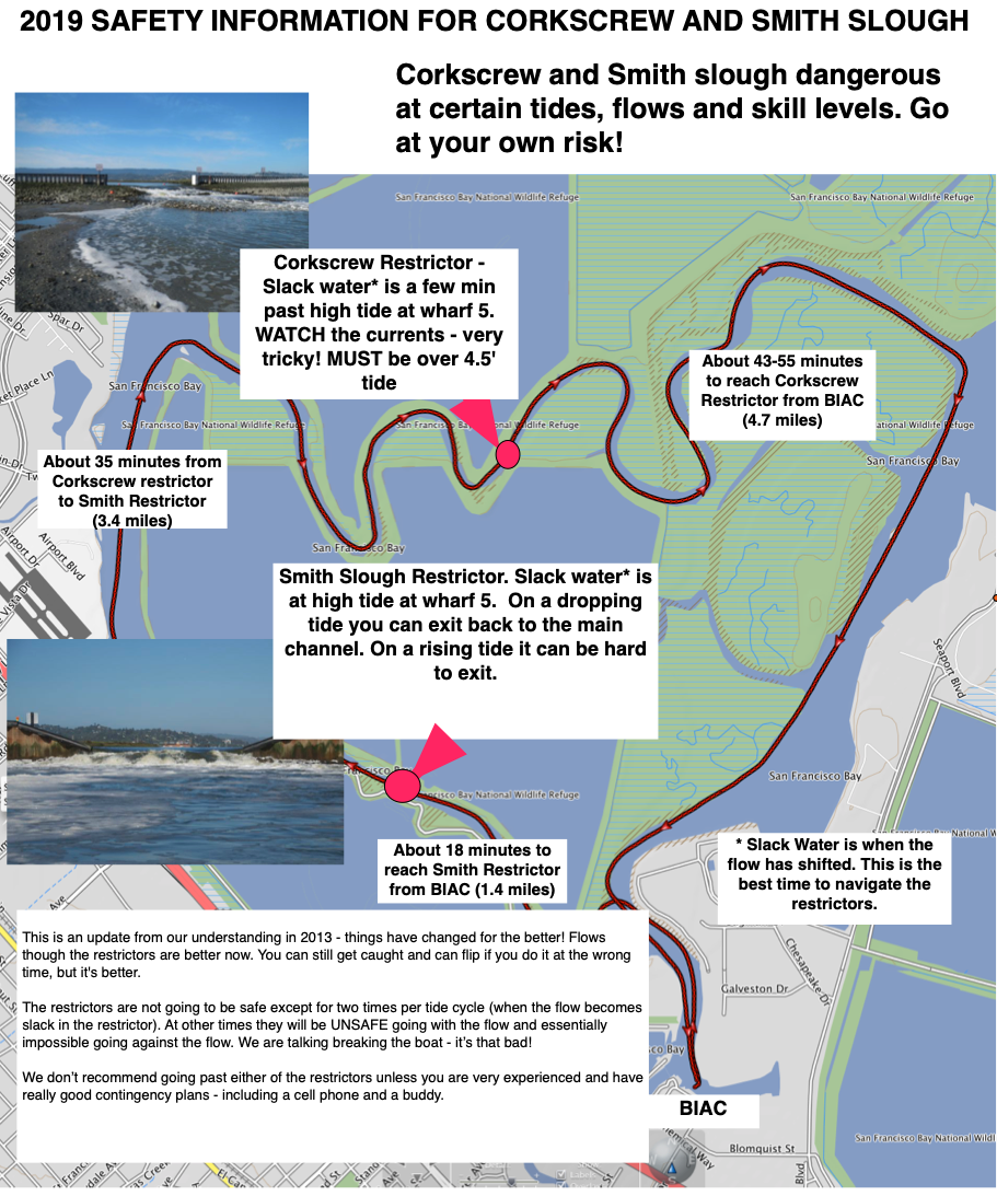
Here is a short version for Corkscrew Slough:
- Distance: From BIAC around Corkscrew and back is about 9.5 miles = 15.2 km
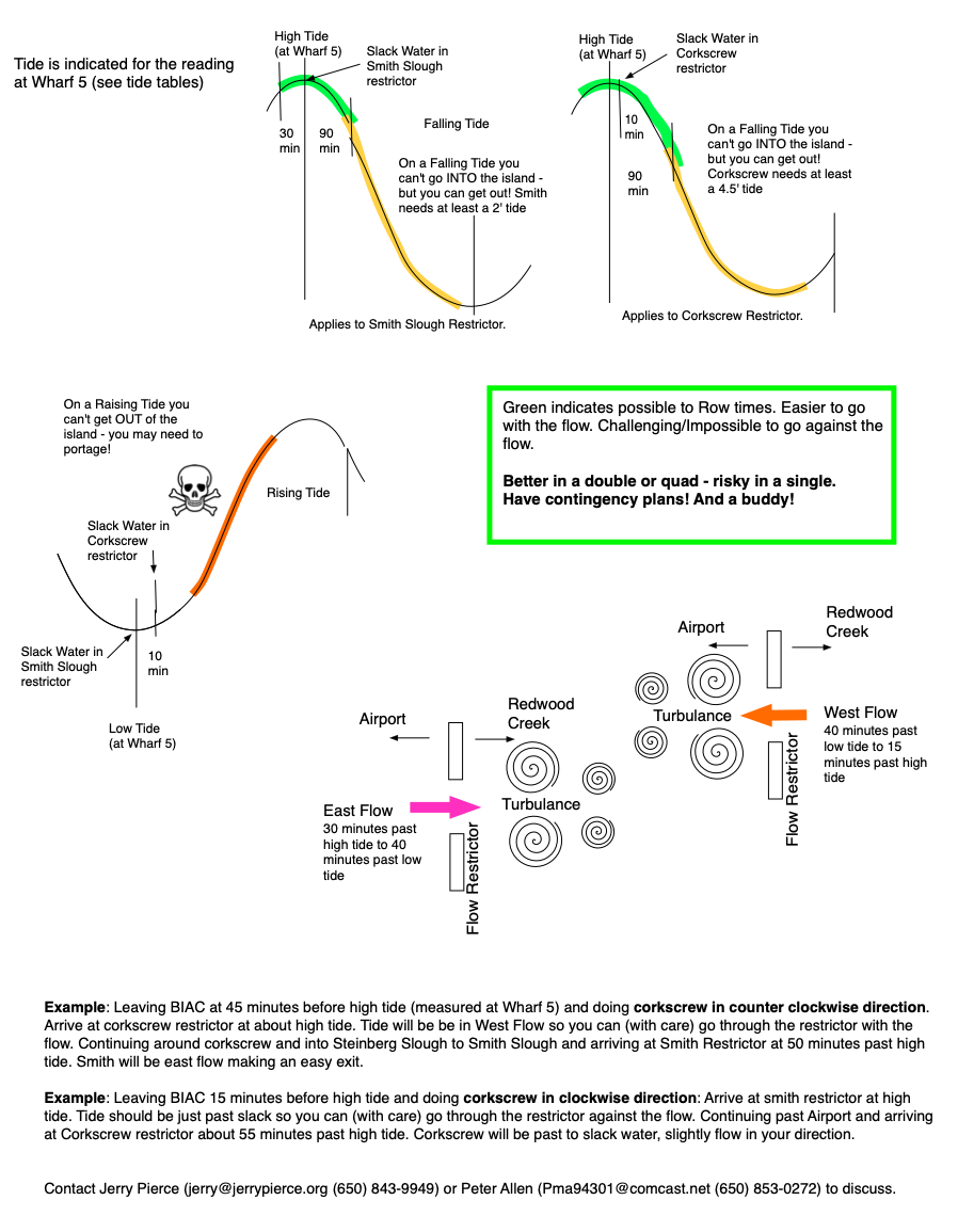
- Clockwise: If you leave BIAC at about 15 minutes prior to High Tide as measured at Wharf 5 in the harbor and go clockwise, you will have a good safe row through both Flow Restrictors. The Smith Restrictor will be very close to slack tide and Corkscrew will be flowing slightly away from Redwood Shores.
- Counter Clockwise: If you leave BIAC 45 minutes before High Tide as measured at Wharf 5 you can go counter clockwise. You will go with the flow at Corkscrew and again with the flow at Smith. There will be slightly more squirrelly water than the clockwise row - but still easy.
At any tide level you can enter the Corkscrew from the east end near the Wires just beyond the Port of Redwood City. But if you are outside of the prescribed tide profile, you will not be able to get safely past the Corkscrew Restrictor. Instead, enjoy the resident harbor seals and return back through the harbor.
High tides will always be above 4'. Above 5.5' the sloughs are deep almost everywhere. At a 4' to 5' tide there are many places where it is shallow - you may need to go to the deeper part of the channel. Where is the deeper channel? Ask Jerry Pierce or Peter Allen!
There are other options available for rowing at low tides. If you want to know more, talk to Peter or Jerry. They are more than happy to talk about them.
Background
Bair Island has had modifications to restore pre-industrial tidal flow to this wetland while not adversely affecting the Port of Redwood City and upper Redwood Creek (with increased silting and flow). The effort is led by the US Fish & Wildlife Service, with the work contracted out to Ducks Unlimited. BIAC was involved in 2011 and early 2012 in understanding the plans and ensuring that public aquatic access would remain reasonable during and after construction.
During construction in 2012 and early 2013, access to Corkscrew and Smith Sloughs was interrupted, yet the result is a whole new world of aquatic adventures. Landings on Bair Island are still be prohibited, but smart attention to tidal patterns will present you with a new adventure and public access to a stunning wetland and wildlife preserve. The usual routes around Bair Island have many new tidal flows and areas to explore. Watch for squirrely marine flows in and out of the new levee breaches as well as shifting mud flats. These new flows will scourge out Steinberger Slough - a process that will continue for decades.
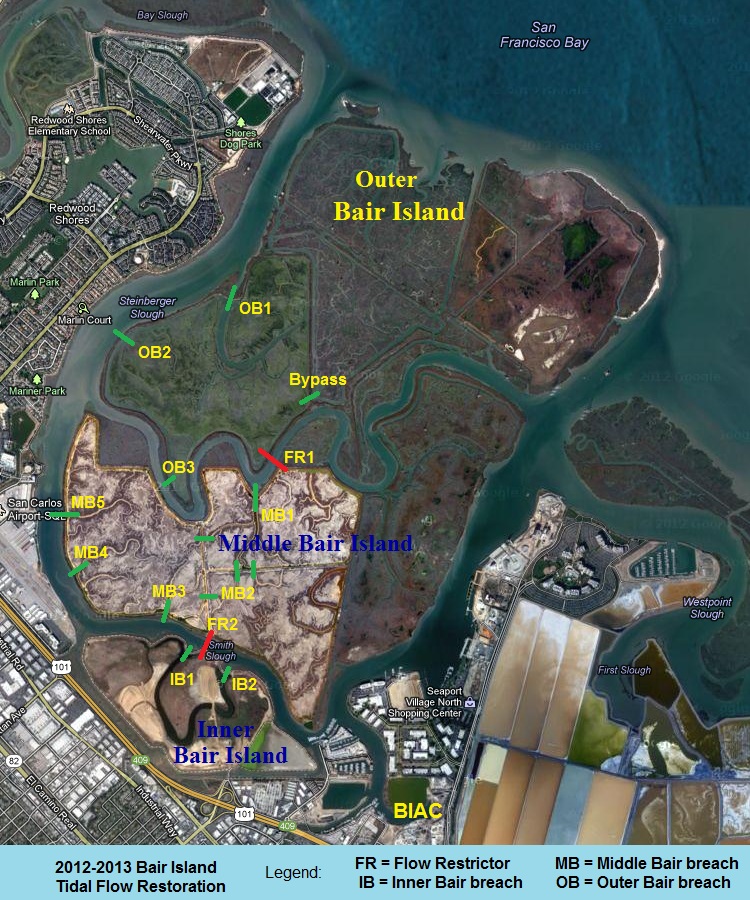
You can follow the changes starting today or enjoy them anytime. Click on the image below for detailed plans of the work. Basically the work involves:
-
Creating 2 Flow Restrictors and
-
Breaching the levees in many places
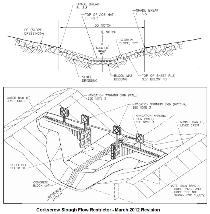
Two "Flow Restrictors" have been built - one halfway through Corkscrew Slough (FR1) and the other halfway up Smith Slough (FR2) - to prevent additional tidal flow and silting into Redwood Creek and the Port of Redwood City (saving million$ in dredging fees). These micro dams encourage more tidal flow into Bair Island from Steinberger Slough to the north and should scourge out a deeper channel there as more water flows in and out each day. These structures will still allow aquatic access through Corkscrew and Smith at current tide levels (5' and 2' respectively).
The old salt pond levees inside of Middle and Outer Bair Island are breached in many places to restore former sloughs and to recreate the original tidal wetlands of Bair Island. See the image below for details. These breaches are about 50' wide and create new tidal rushes in and out during ebb and flows - so watch for marine flows that could upset your paddling or rowing.
At the time of this writing (February 2013) the Corkscrew (FR1) and Smith (FR2) Restrictors are complete as are the Outer and Middle Bair Island breaches. The dynamic current flows are hazardous. At peak flows the drop from one side to the other of a flow restrictor can be as much as 3 feet.
© Bair Island Aquatic Center 2024 |